10-10-2026
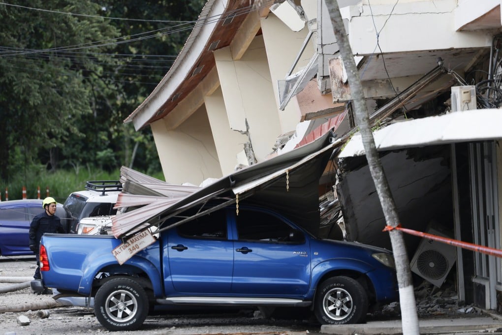
A series of strong earthquakes struck Panama on Friday, 9 October, damaging buildings and prompting evacuations. The tremors sent residents into the streets of Panama City and were also felt in Colombia. In Penonomé, part of a cathedral—including one of its spires—collapsed, and footage showed extensive damage to a nearby hotel. Residents in Herrera province reported cracks and damage to their homes. Tocumen International Airport temporarily suspended operations but later reopened; the Panama Canal continued operating normally. The US Geological Survey said the first earthquake occurred at a depth of 10 kilometres, about 10 kilometres southwest of Pitaloza Arriba in Herrera province. Tsunami warnings were issued for Panama and several neighbouring countries. Panama's president said no deaths had been reported in the immediate aftermath, while emergency teams continued assessing the damage. The article places the event in the broader context of Panama's location along the Pacific Ring of Fire, a region of significant seismic and volcanic activity where most of the world's earthquakes occur.
Entities: Panama, Panama City, Penonomé, Herrera province, Pitaloza Arriba • Tone: urgent • Sentiment: negative • Intent: inform
10-10-2026
The report says Panama’s president has declared a major disaster after two earthquakes and dozens of aftershocks struck the country’s south. The main shocks, measured at magnitude 7.5 and 6.6, shook Herrera province on Friday. They destroyed buildings and disrupted power supplies. The article describes the event as devastating but provides no further details about casualties, the number or condition of damaged buildings, the extent of outages, or which communities were most affected.
The report also does not identify the president by name or outline what the major-disaster declaration entails. It offers no information about evacuations, emergency services, relief operations, infrastructure damage beyond buildings and power supplies, or the likelihood of further aftershocks. As a result, the account is a brief initial description rather than a comprehensive assessment of the earthquakes’ consequences. Its central points are the two powerful shocks, continued aftershock activity, damage and disruption in Herrera province, and the national government’s disaster declaration. The article was published on October 10, 2026.
Entities: Panama, Herrera province, Panama’s president, Magnitude 7.5 earthquake, Magnitude 6.6 earthquake • Tone: urgent • Sentiment: negative • Intent: inform
10-10-2026
Two powerful earthquakes struck Panama on Friday, beginning with a magnitude 7.7 quake near the country’s southern tip and followed about two and a half hours later by a magnitude 6.6 quake. The first earthquake was centered near Pitaloza Arriba; the second occurred near Río Grande on the Pacific coast. The shaking was felt in Panama City, where residents evacuated buildings, and the U.S. Pacific Tsunami Warning Center initially issued a tsunami warning before saying the threat had passed.
Panamanian President José Raúl Mulino said no deaths or injuries had been documented as of Friday evening, while warning that the situation could change. Later reports from civil protection official Omar Smith described several injuries, including a person struck by debris in Penonomé. Damage was concentrated in the central provinces of Veraguas, Herrera and Los Santos. Reports included a partial collapse and cracks at a cathedral, damage to government and hotel buildings, the reported collapse of the historic Church of San Atanasio, and large road fissures. More than 45 aftershocks were recorded, some reaching magnitude 5.8.
Tocumen International Airport temporarily suspended operations after the first quake and reopened later that afternoon. Panama Canal operations continued while technical teams inspected facilities. The article places the event in the context of recent destructive earthquakes in Venezuela and Colombia and recalls a 1991 earthquake near Costa Rica that caused deaths and widespread damage in Panama’s Bocas del Toro region. Panama’s location along the Pacific Ring of Fire and the interaction of several tectonic plates make earthquakes common. Colombia expressed support, while the U.S. Embassy said it was monitoring the aftermath and checking on American citizens.
Entities: Panama, Panama City, Pitaloza Arriba, Río Grande, José Raúl Mulino • Tone: neutral • Sentiment: negative • Intent: inform
10-10-2026
A series of strong earthquakes struck Panama on Friday, 9 October, led by a magnitude 7.7 quake followed by a 6.6 aftershock and numerous tremors. The shaking damaged buildings and prompted evacuations. People in Panama City rushed into the streets, and tremors were also reported in Colombia. In Penonomé, part of a cathedral collapsed, including one of its spires, while footage showed extensive damage to a nearby hotel. Residents in Herrera province reported cracks and damage to their homes.
Tocumen International Airport temporarily suspended operations but later reopened. The Panama Canal continued operating normally. The US Geological Survey said the first earthquake occurred at a depth of 10 kilometres, around 10 kilometres southwest of Pitaloza Arriba in Herrera province. Tsunami warnings were issued for Panama and several neighbouring countries.
Panama’s president said no deaths had been reported in the immediate aftermath. Emergency teams were still assessing the damage, so the situation remained subject to further updates. Panama is located along the Pacific Ring of Fire, a large zone of seismic and volcanic activity where most of the world’s earthquakes occur.
Entities: Panama, Panama City, Penonomé, Herrera province, Pitaloza Arriba • Tone: urgent • Sentiment: negative • Intent: inform
10-10-2026
The article reports that two powerful earthquakes, measured at magnitudes 7.7 and 6.6, struck Panama on Friday afternoon, followed by a series of aftershocks. According to the US Geological Survey (USGS), the tremors caused buildings to collapse near the epicentre and prompted evacuations in different parts of the country. The first earthquake was felt as far away as neighbouring Colombia.
The USGS placed the first quake’s epicentre about 10 kilometres (six miles) southwest of Pitaloza Arriba, a remote community in the central province of Herrera. It occurred at a depth of 10 kilometres. The agency’s estimate of the first quake’s magnitude changed several times: it was initially reported as magnitude 8, then revised to 7.6, and later listed as 7.7.
The report also describes residents visibly shaken in Panama City gathering outside while they waited for information about the quake’s impact. The article gives no details about casualties, the extent of damage beyond collapsed buildings near the epicentre, or the number of people evacuated. It likewise does not provide further information about the second quake or the aftershocks. Overall, the account focuses on the earthquakes’ strength and location, the immediate effects reported by the USGS, and the public response as people sought updates.
Entities: Panama, Pitaloza Arriba, Herrera province, Panama City, Colombia • Tone: neutral • Sentiment: negative • Intent: inform